MODIS for North American Carbon Program
The North American Carbon Program (NACP) provides the scientific foundation to inform future policy decisions involving the carbon cycle, such as managing carbon sources and sinks through efficient and effective options to reduce emission and enhance carbon sinks. As per its Wikipedia entry: “The central objective of NACP is to measure and understand carbon stocks and sources and sinks of carbon dioxide (CO2), methane (CH4), and carbon monoxide (CO) in North America and adjacent ocean regions.” It serves a major component within the U.S. Climate Change Science Program.
Project/PI Names
Principal Investigator: Jeff Morisette
Co Investigators: Robert Wolfe, William Ridgway, Michael Teague, Edward Masuoka
NASA ACCESS (2005)
Introduction
Earth observing satellites are major providers of spatial and temporal information that are required to address the carbon accounting sought by the NACP. The Moderate resolution Imaging Spectroradiometer (MODIS) instrument is a major contributor to regional and global analyses that are critical to NACP. Regional analyses performed by NACP help connect atmospheric constituents (mainly greenhouse gases) with surface processes on the land and ocean. MODIS data remain key to providing detailed spatial and temporal information about the surface conditions/dynamics; they also help refine physical models of diverse phenomena such as aerosol/cloud interactions, radiative forcing and aerosol/chemical transport. This project addresses a major research challenge: how to acquire EOS MODIS data at suitable spatial-temporal resolutions, and in formats that support data integration with modelling applications.

The Earth Observing System’s (EOS) Terra platform, which hosts the MODIS instrument, was launched in December 1999. Early in the mission, NASA-funded NACP application science investigators experienced some challenges in using MODIS data. The “one-size-fits-all” approach was not deemed to satisfactorily address the NACP investigator’s needs. They viewed the existing data/tools as providing only a fraction of the required functionality alongside significant overheads in ingesting and processing MODIS data for particular uses. Hence, they perceived all such additional efforts as often prohibitive, and not serving to their full potential within the NACP.
A NASA Advancing Collaborative Connections for Earth System Science (ACCESS) project awarded in 2005, MODIS-for-NACP was formally named “Improving access to Land and Atmosphere science products from Earth Observing Satellites: helping NACP investigators better utilize MODIS data products.” Its defining strategy was to offer a wide range of processing capabilities that were applied to a selection of MODIS land and atmosphere products deemed important to a focus group of NACP investigators. The goal in its first year was to develop the capacity to provide these investigators specific products/tools that precisely catered to their requirements. During the second and third years, their plans called for an expansion of this capacity to reach an operational status.
Besides the NACP’s concerns, atmospheric researchers identified certain gaps in the MODIS data distribution process that include the following:
- Parameter reprojection onto user-specified fixed grids including day-to-day time-series on such grids
- Custom products that combine satellite parameters and simultaneous ancillary meteorological data such as wind fields
- A menu of product and image formats that allows common data projections acquired from various sources, and
- A mechanism that enables machine-to-machine ordering besides most web-based functionalities via scripts
Aim and Objectives
- Facilitate the availability of EOS MODIS data at appropriate spatial and temporal resolutions, and in data formats that support their data integration with modelling applications.
- Identify a set of processing capabilities (for instance, pre-processing routines that filter by quality-assurance bits, and gap-filling within a time-series selection) that are applied to a set of MODIS land and atmosphere products that were considered as valuable to NACP researchers.
How does MODIS-for-NACP benefit end-users the most?
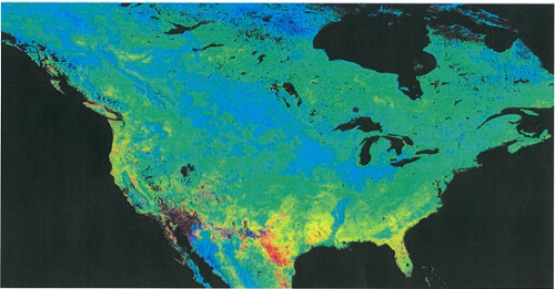
The NACP’s central objective is to measure and understand carbon stocks alongside the sources and sinks of carbon dioxide, methane, and carbon monoxide in North America and its adjacent ocean basins. The MODIS-for-NACP project provides various application-ready Terra-MODIS data products that measure NDVI, EVI and LAI/fPAR to facilitate the land and atmosphere climate modelling community as it builds the scientific foundation to develop carbon accounting on regional to continental scales.
Data Products
| LAI/fPAR* | ||
| MOD15A2PHN | MODIS/Terra LAI-FPAR Phenology annual L4 Global 1km SIN Grid | View MOD15A2PHN data |
| MOD15A2GFS | MODIS/Terra Gap-Filled, Smoothed LAI-FPAR 8-Day L4 Global 1km SIN Grid | View MOD15A2GFS data |
| EVI** | ||
| MOD09A1G_EVI | MODIS/Terra Gap-Filled, Smoothed EVI 8-Day L4 500m SIN Grid | View MOD09A1G_EVI data |
| MOD09A1P_EVI | MODIS/Terra EVI Phenology annual L4 500m SIN Grid | View MOD09A1P_EVI data |
| MOD09Q1G_EVI | MODIS/Terra Gap-Filled, Smoothed EVI 8-Day L4 250m SIN Grid | View MOD09Q1G_EVI data |
| MOD09Q1P_EVI | MODIS/Terra EVI Phenology annual L4 250m SIN Grid | View MOD09Q1P_EVI data |
| NDVI** | ||
| MOD09A1G_NDVI | MODIS/Terra Gap-Filled, Smoothed NDVI 8-Day L4 500m SIN Grid | View MOD09A1G_NDVI data |
| MOD09A1P_NDVI | MODIS/Terra NDVI Phenology annual L4 500m SIN Grid | View MOD09A1P_NDVI data |
| MOD09Q1G_NDVI | MODIS/Terra Gap-Filled, Smoothed NDVI 8-Day L4 250m SIN Grid | View MOD09Q1G_NDVI data |
| MOD09Q1P_NDVI | MODIS/Terra NDVI Phenology annual L4 250m SIN Grid | View MOD09Q1P_NDVI data |
* Based on standard MODIS MOD15A2 8-day, 1km products.
** Based on standard MODIS MOD09A1 8-day, 500m & MOD09Q1 8-day, 250m products.
Product Information
| Short-names | MOD15A2PHN, MOD15A2GFS, MOD09A1G_EVI, MOD09A1P_EVI, MOD09Q1G_EVI, MOD09Q1P_EVI, MOD09A1G_NDVI, MOD09A1P_NDVI, MOD09Q1G_NDVI, MOD09Q1P_NDVI |
| Long-names | Refer to Data Products Table above |
| Platform/Instrument | Terra/MODIS |
| Processing Level | Level-4 |
| Spatial Resolution | 250 m, 500 m, 1 km |
| Temporal Resolution | 8-day, Annual |
| File Sizes (Average) |
MOD09A1G_EVI: 13.9 MB MOD09A1P_EVI: 57.5 MB MOD09Q1G_EVI: 55.2 MB MOD09Q1P_EVI: 228.6 MB MOD09A1G_NDVI: 14.2 MB MOD09A1P_NDVI: 58.9 MB MOD09Q1G_NDVI: 55.8 MB MOD09Q1P_NDVI: 232 MB MOD15A2PHN: 36.3 MB MOD15A2GFS: 9.5 MB |
| Data Formats | HDF4 |
| File Naming Convention |
MOD09Q1G_NDVI.A2006049.h08v05.006.2018287004638.hdf
|
| Dataset Originator/Creator | MODIS Adaptive Processing System (MODAPS) |
| Citation | See below |
Product Documentation
| Collection-6 MODIS-for-NACP Gap-Filled-Smoothed Product User Guide (PDF) | This guide describes the gap-filled, smoothed products created by the MODIS-for-NACP project, and contains information about the various C6 products and their formats. |
| Collection-6 MODIS-for-NACP Phenology Product User Guide (PDF) | This guide describes the Phenology products created by the MODIS-for-NACP project, and contains information about the various C6 Phenology products and their formats. |
| TIMESAT web site | http://web.nateko.lu.se/timesat/timesat.asp |
| MODIS-for-NACP Proposal | Final project proposal submitted to NASA ROSES/ACCESS, which presents the project rationale and processing strategy. |
Published Papers
Citation Information
In the event that data from the MODIS-for-NACP project are incorporated in your research, please use the following acknowledgment within your published work:
“These data products are processed and distributed by the MODIS-for-NACP system developed under Cooperative Agreement NNH05ZDA001N-ACCESS with NASA.”
If possible, please e-mail or send us reprints/citations of papers or oral presentations that are based on MODIS-for-NACP data (see below for email and mailing address). This will help us to stay informed regarding how our data are being used.
There are no restrictions for use of data from MODIS-for-NACP project unless otherwise expressly stated.