GEO-LEO Dark Target Aerosol
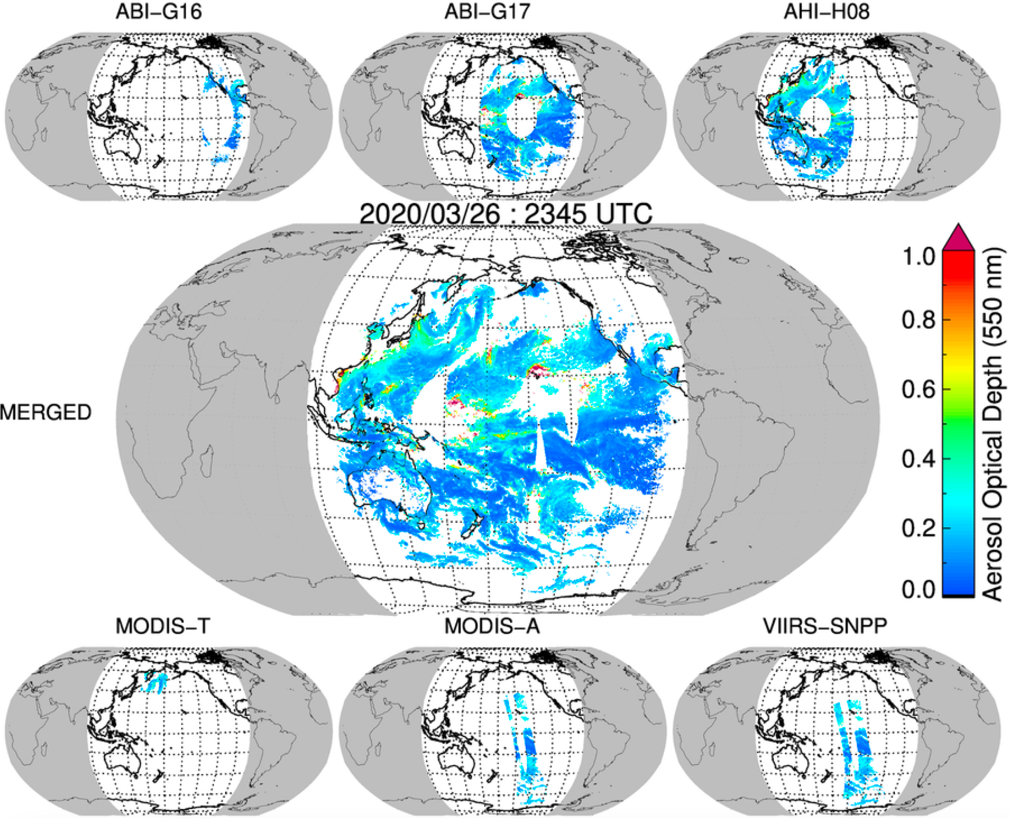
Examples of 30-minute coverages at quarter-degree resolution for each sensor and merged AOD datasets on March 26, 2020, at 2345 UTC.
The Geostationary Earth Orbit (GEO) – Low-Earth Orbit (LEO) Dark Target Aerosol is a NASA project funded under the Making Earth System Data Records for Use in Research Environments (MEaSUREs) program (selected in 2017).
Led by Robert Levy, its Principal Investigator, the official name of this project is "Adding High Temporal Resolution to the Global Long-term Aerosol Data Record: A Synergy of LEO and GEO." The result of this project is a suite of structurally consistent global aerosol products from GEO and LEO-based imagers, spanning the period from January 2019 to December 2022.
The GEO-LEO Dark Target Aerosol product suite includes retrievals based on the sensors’ native spatial resolutions and temporal cadences (e.g., Level-2 representing GEO Full Disks and LEO Granules), and gridded products (Level-3) that represent the union of all imagers at 0.25° x 0.25° latitude/longitude, at half-hour and daily aggregations.
Introduction
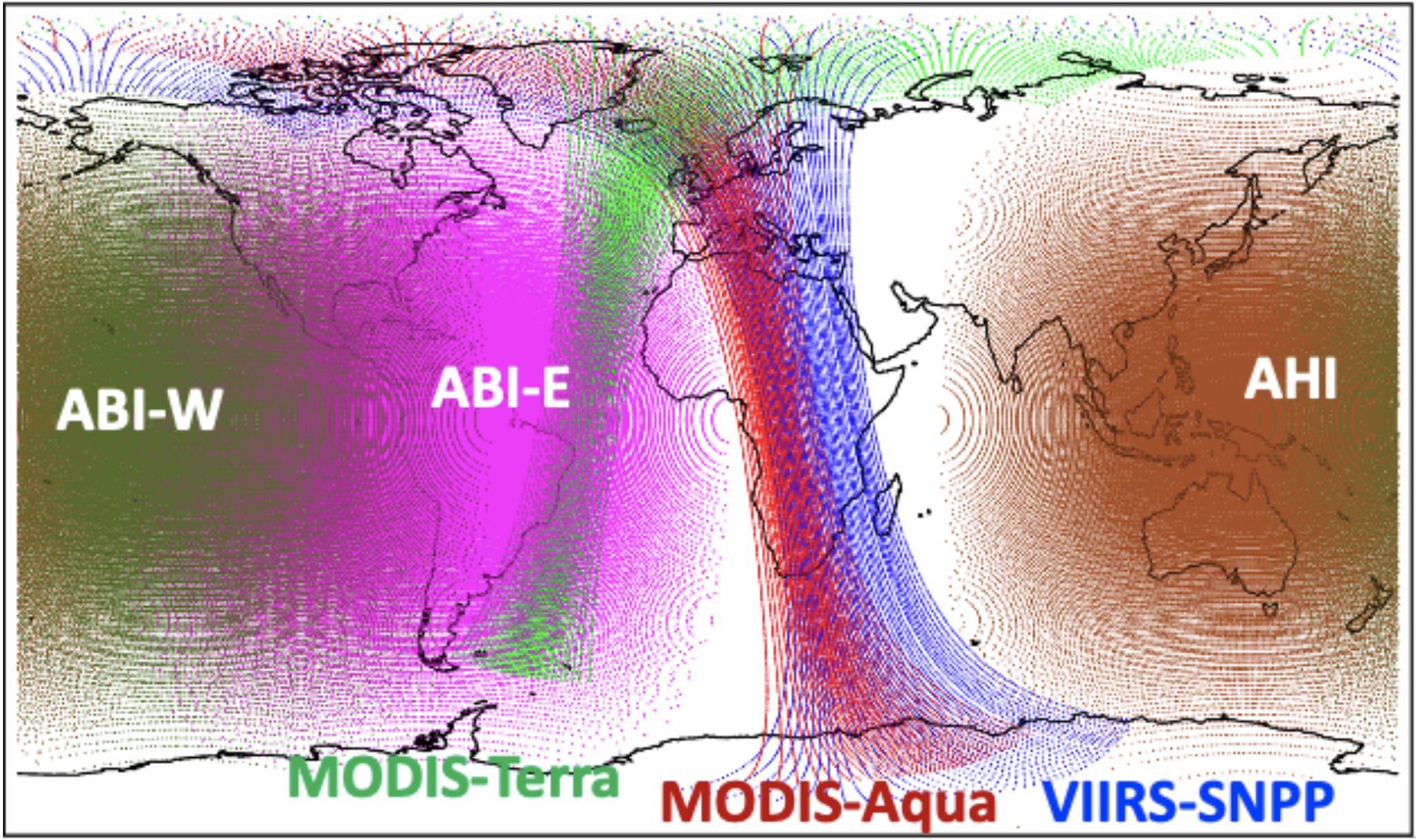
GEO-LEO view of the globe, created by joining ABIs on GOES-West and GOES-East, AHI on Himawari, MODIS on Terra and Aqua, and VIIRS on Suomi-NPP.
Aerosol Optical Depth (AOD), related to the concentration of aerosols within Earth’s atmosphere, is a key parameter for estimating aerosol impact on weather, climate, and Air Quality. When applied to Moderate resolution Imaging Spectroradiometer (MODIS), the Dark Target (DT) Aerosol Retrieval Algorithm derives global AOD and other aerosol properties on approximately a daily basis. However intense aerosol plumes, such as dust and smoke, can have AODs that vary diurnally or even more rapidly. Even with two MODIS sensors in space (on Terra and Aqua), and now multiple Visible Infrared Imaging Radiometer Suite (VIIRS) sensors (on Suomi-NPP and NOAA’s JPSS series), AOD information is still limited to a few times per day. To increase the frequency of aerosol observations provided by MODIS and VIIRS in LEO, we turn to the emerging “ring” of GEO-based imagers, each providing a “Full Disk” view of Earth at sub-hourly intervals.
Here, we use a special version of the DT aerosol retrieval algorithm to retrieve AOD and other aerosol parameters on eight sensor/platform combinations. The four GEO sensors include the Advanced Baseline Imagers (ABI) on both GOES-16 (GOES-East) and GOES-17 (GOES-West), and Advanced Himawari Imagers (AHI) on Himawari-8 and Himawari-9. The four LEO sensors include MODIS on both Terra and Aqua, and VIIRS on both Suomi-NPP and NOAA-20. The addition of the LEO sensors strengthens a major goal of this project, which is to render a consistent science maturity level across DT aerosol products derived from both types and sources of orbital satellites. With the possibility of AOD retrievals from one or more LEO and/or GEO sensors at any single time interval, a combined GEO-LEO aerosol product increases confidence and retrieval coverage that should benefit and improve many applications.
Aim/Objectives
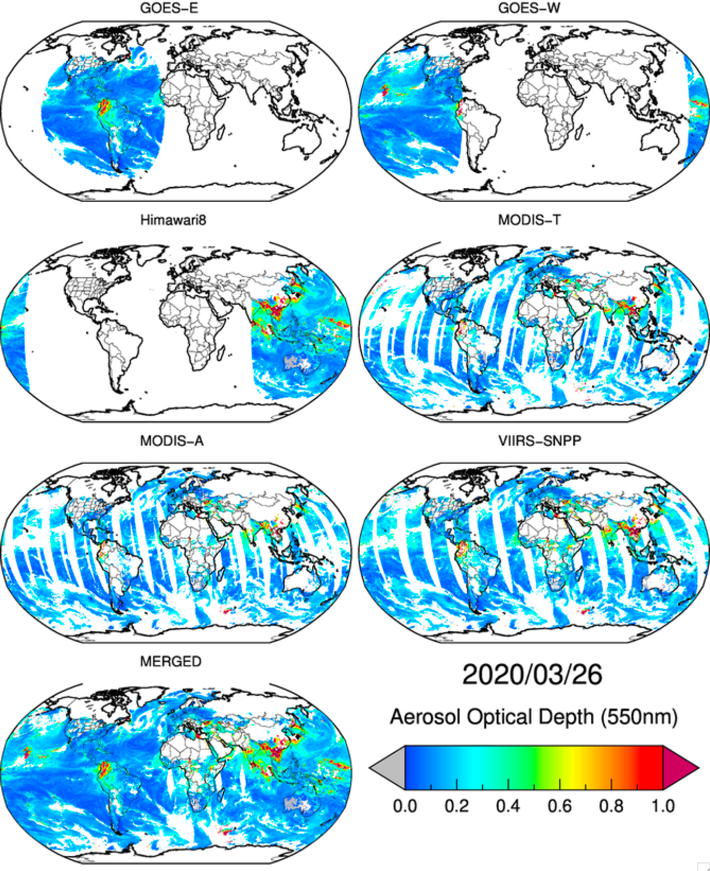
Daily average aerosol optical depth (550 nm) on March 26, 2020, retrieved by six LEO and GEO sensors and merged quarter degree product. The daily averages (daytime) are calculated using 48 of 30 minutes, quarter-degree gridded files.
The overall aim of this GEO-LEO Dark Target Aerosol project was to create a global, synoptic, relatively high temporal resolution aerosol data set can make substantial improvement to the global representation of the modeled aerosol system. To accomplish this aim, the DT aerosol retrieval algorithm was adapted to run on multiple LEO and GEO sensors in a consistent way.
Some of the objectives of this project include:
- Porting the DT algorithm to the GEO sensors,
- Creating Level-2 products from each LEO and GEO sensor that all had the same look and feel (e.g., data formats, variable names),
- Working towards Open Science objectives that facilitates running the algorithm on many platform and machine environments, and
- Using data fusion techniques to create a gridded Level-3 product that represents a merge of all sensors for a given time interval.
The result is a union of Level-2 and Level-3 products, which extends the MODIS and VIIRS global record, expands data availability diurnally, and provides an easy-to-use product for assimilation, model comparison, and estimates of radiative forcing.
Benefits
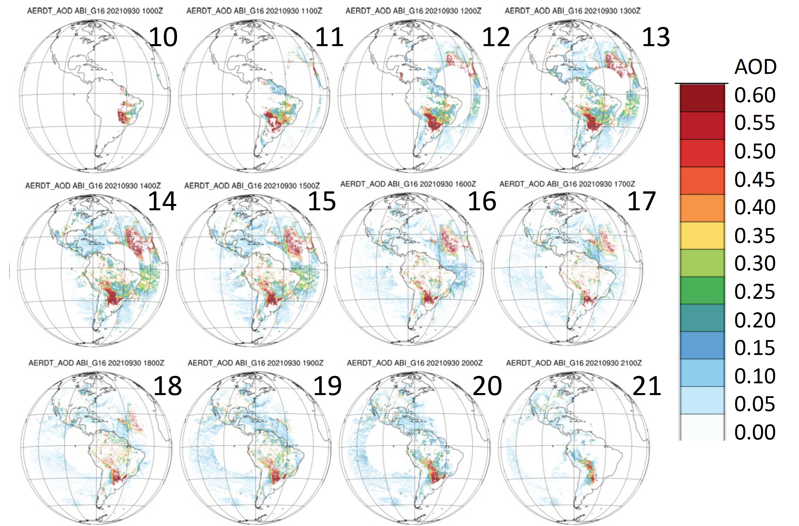
Hourly AOD coverage from GOES-East from 10 – 21 UTC provide full-disk, multi-spectral observations every 10 minutes that facilitates monitoring rapid aerosol changes.
Aerosol optical depth measurements from GEO satellites are retrieved at full-disk-resolution every 10 to 15 minutes, which allows us to characterize aerosol changes on time scales less than a day. This can facilitate our ability to track rapid changes and movement in smoke and dust plumes that can severely impact air quality. It can further help gather information from gaps in clouds or glint that LEO sensors (e.g., MODIS and VIIRS) do not retrieve. The aerosol diurnal cycle's statistics is useful to study relationships with meteorology (e.g., general cloud formation, land/sea breezes, boundary layer dynamics), and human activity (e.g., vehicular rush-hour air pollution, etc.).
The Level-2 GEO-LEO products could benefit a variety of science and applications uses, including (but not limited to) the following:
- Basic research towards understanding aerosols' global loading, spatial extent, and variability.
- Evaluating and improving aerosol transport modeling, including defining aerosol pathways and downstream impacts.
- Initializing models for data assimilation.
- Estimating aerosols' global radiative effects, especially during the times of day that are not served by MODIS or VIIRS observations at ±1.5 hours from local noon.
Output products
| Platform | Sensor | Temporal Resolution | Spatial Resolution | Product |
|---|---|---|---|---|
|
GOES-16
|
Advanced Baseline Imager (ABI)
|
10 min. (15 min. before April 2019)
|
10 km
|
|
|
GOES-17
|
Advanced Baseline Imager (ABI)
|
10 min. (15 min. before April 2019)
|
10 km
|
|
|
Himawari-8
|
Advanced Himawari Imager (AHI)
|
10 min.
|
10 km
|
|
|
Himawari-9
|
Advanced Himawari Imager (AHI)
|
10 min.
|
10 km
|
|
|
SNPP
|
Visible-Infrared Imaging Radiometer Suite (VIIRS)
|
6 min.
|
6 km
|
|
|
NOAA-20
|
Visible-Infrared Imaging Radiometer Suite (VIIRS)
|
6 min.
|
6 km
|
|
|
Terra
|
Moderate-resolution Imaging Spectroradiometer (MODIS)
|
5 min.
|
5 km
|
|
|
Aqua
|
Moderate-resolution Imaging Spectroradiometer (MODIS)
|
5 min.
|
5 km
|
|
|
Merged
|
Merged Level-3
|
30 min.
|
0.25˚
|
|
Project documentation
GEO-LEO Dark Target Aerosol Products User Guide
GEO-LEO Dark Target Aerosol Project ATBD
Published Papers
- Gupta, P., Levy, R. C., Mattoo, S., Remer, L., Zhang, Z., Sawyer, V., Wei, J., Zhao, S., Oo, M., Kiliyanpilakkil, V. P., and Pan, X. (2024). Increasing Aerosol Optical Depth Spatial and Temporal Availability By Merging Datasets from Geostationary And Sun-Synchronous Satellites, Atmospheric Measurement Techniques Discussions [preprint], [https://doi.org/10.5194/amt-2023-259] (In review).
- Kim, M., Levy, R. C., Remer, L. A., Mattoo, S., & Gupta, P. (2024). Parameterizing spectral surface reflectance relationships for the Dark Target aerosol algorithm applied to a geostationary imager, Atmospheric Measurement Techniques Discussions [preprint], [https://doi.org/10.5194/amt-2023-128], in review, 2023. Accepted for publication in Atmospheric Measurement Techniques on 17 Jan 2024.
- Shi, Y. R., Levy, R. C., Remer, L. A., Mattoo, S., & Arnold, G. T. (2024). Investigating the spatial and temporal limitations for remote sensing of wildfire smoke using satellite and airborne imagers during FIREX_AQ, Journal of Geophysical Research: Atmospheres, 129, e2023JD039085. [https://doi.org/10.1029/2023JD039085]
- Remer L. A., Levy R. C., Mattoo S., Tanré D., Gupta P., Shi Y., Sawyer V., Munchak L. A., Zhou Y., Kim M., et al. (2020). The Dark Target Algorithm for Observing the Global Aerosol System: Past, Present, and Future. Remote Sensing, 12(18):2900. [https://doi.org/10.3390/rs12182900]
- Gupta, P., R. C. Levy, S. Mattoo, L. A. Remer, R. E. Holz, & A. K. Heidinger. (2019). Retrieval of aerosols over Asia from the Advanced Himawari Imager: Expansion of temporal coverage of the global Dark Target aerosol product. Atmospheric Measurement Techniques, 12 6557-65/7 [https://doi.org/10.5194/amt-12-6557-2019]
Citation Information
If you incorporate products from the GEO-LEO Dark Target Aerosol project in your research or applications, please use the following acknowledgment within your published work:
“These data products are processed by the MEaSUREs GEO-LEO Dark Target Aerosol project and distributed by the Level-1 and Atmosphere Archive & Distribution System (LAADS) Distributed Active Archive Center (DAAC) at the Goddard Space Flight Center.” If possible, please e-mail or send us reprints/citations of papers or oral presentations that are based on the GEO-LEO aerosol products (see below for email). This will help us to stay informed regarding how our data are being used.
There are no restrictions for use of data from the GEO-LEO Dark Target Aerosol project unless otherwise expressly stated. If you have any questions, please contact us.